Sunday, August 11, 2013

Route 89 - Traveling South -- of Montpelier and Northfield, NH

We spent the weekend with the Winnebago-Itasca RV Club (WIT, specifically the Granite State Winnies, the subchapter we belong to.  It was our Northern New-England Rally, and the 2nd one that we attended.

Below on the map, in the extreme upper right corner you will see "Lake Champlain".  The red post mark is Essex Junction.  Along the right margin, center, of the map, you will see the White Mountain National Forest (in Green) and Mt. Washington.  At the lower right corner you will see Laconia.
Our Rally was held in Essex Junction, VT.  Each year a different State hosts the Rally, and the States include Vermont, New Hampshire and Maine.  This years theme was the 50's & 60's, complete with a sock hop on Friday night.

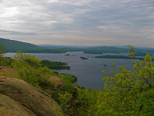
The pictures below were taken on the ride home, and were just below Montpelier, and Northfield, traveling south on Route 89.


Sunday, July 28, 2013

Flume Gorge, New Hampshire

The Flume Gorge
Franconia Notch State Park, NH
(603) 745-8391
flumegorge.com
Click on any or all pictures to enlarge.

We visited the Flume Gorge with our friends this past weekend.  The entire walking path from the visitor center around and back is 2 miles.  The information is gathered from the brochure the welcome center gives you upon admission.  These are the pictures we took.


Built in 1886, crosses Pemigewasset River.  Pemigewasset means "swift" or "rapid current" in the Abenaki Indian language.

Table Rock is a section of Conway granite 500 feet long and 75 feet wide.

Nearly 200 million years ago in Jurassic times, the Conway granite that forms the walls of the Flume was deeply buried molten rock.

As it cooled, the granite was broken by closely spaced vertical fractures which lay nearly parallel in a northeasterly direction.

Sometime after the fractures were formed, small dikes of basalt were forced up along the fractures.

The basalt came from deep within the earth as a fluid material, and bacause of pressure, was able to force the Conway granite aside.  The basalt crystallized quickly against the relatively cold granite.
Because of this quick cooling, the basalt is a fine-grained rock.  Had this material ever reached the surface, it would have become lava flows.

Erosion gradually lowered the earth's surface and exposed the dikes.  As the overlying rock was worn away, pressure was relieved and horizontal cracks developed, allowing water to get into the rock layers.
On the walls of the Gorge small trees are growing.

Climbing higher and higher up the Gorge

The basalt dikes eroded faster than the surrounding Conway granite, creating a deepening valley where the gorge is now.


Getting closer...
Heading to the top of the Flume

Notice the Tree w/the horizontal trunk, at top of wall


The Falls were formed during the great storm of 1883

At the top of the Flume is Avalanche Falls.  A 45-foot waterfall

Monday, May 20, 2013

Springtime along the Kancamagus Highway and Franconia Notch

We spent the day driving along the White Mountains

Springtime in New England


Springtime


The colors are delightful


Driving into Franconia Notch

Cars are pin pricks against the Mountains


And you drive on into the Notch


Saturday, October 13, 2012

Meredith

October 10, 2012
Jim, Tucker and I on our after dinner walk

Our Pond


A glimpse of the Town and Bay in the background